[fusion_builder_container hundred_percent=”no” hundred_percent_height=”no” hundred_percent_height_scroll=”no” hundred_percent_height_center_content=”yes” equal_height_columns=”no” menu_anchor=”” hide_on_mobile=”small-visibility,medium-visibility,large-visibility” status=”published” publish_date=”” class=”our-team” id=”” link_color=”” link_hover_color=”” border_size=”” border_color=”” border_style=”solid” margin_top=”” margin_bottom=”” padding_top=”90px” padding_right=”” padding_bottom=”60px” padding_left=”” gradient_start_color=”” gradient_end_color=”” gradient_start_position=”0″ gradient_end_position=”100″ gradient_type=”linear” radial_direction=”center center” linear_angle=”180″ background_color=”#f9f9f9″ background_image=”” background_position=”center center” background_repeat=”no-repeat” fade=”no” background_parallax=”none” enable_mobile=”no” parallax_speed=”0.3″ background_blend_mode=”none” video_mp4=”” video_webm=”” video_ogv=”” video_url=”” video_aspect_ratio=”16:9″ video_loop=”yes” video_mute=”yes” video_preview_image=”” filter_hue=”0″ filter_saturation=”100″ filter_brightness=”100″ filter_contrast=”100″ filter_invert=”0″ filter_sepia=”0″ filter_opacity=”100″ filter_blur=”0″ filter_hue_hover=”0″ filter_saturation_hover=”100″ filter_brightness_hover=”100″ filter_contrast_hover=”100″ filter_invert_hover=”0″ filter_sepia_hover=”0″ filter_opacity_hover=”100″ filter_blur_hover=”0″][fusion_builder_row][fusion_builder_column type=”1_1″ layout=”1_1″ spacing=”” center_content=”no” link=”” target=”_self” min_height=”” hide_on_mobile=”small-visibility,medium-visibility,large-visibility” class=”team-column goulbourn-township” id=”” background_image_id=”” hover_type=”none” border_size=”0″ border_color=”” border_style=”solid” border_position=”all” border_radius_top_left=”” border_radius_top_right=”” border_radius_bottom_right=”” border_radius_bottom_left=”” box_shadow=”no” box_shadow_vertical=”” box_shadow_horizontal=”” box_shadow_blur=”0″ box_shadow_spread=”0″ box_shadow_color=”” box_shadow_style=”” padding_top=”” padding_right=”” padding_bottom=”” padding_left=”” margin_top=”” margin_bottom=”60px” background_type=”single” gradient_start_color=”” gradient_end_color=”” gradient_start_position=”0″ gradient_end_position=”100″ gradient_type=”linear” radial_direction=”center center” linear_angle=”180″ background_color=”” background_image=”” background_position=”left top” background_repeat=”no-repeat” background_blend_mode=”none” animation_type=”” animation_direction=”left” animation_speed=”0.3″ animation_offset=”” filter_type=”regular” filter_hue=”0″ filter_saturation=”100″ filter_brightness=”100″ filter_contrast=”100″ filter_invert=”0″ filter_sepia=”0″ filter_opacity=”100″ filter_blur=”0″ filter_hue_hover=”0″ filter_saturation_hover=”100″ filter_brightness_hover=”100″ filter_contrast_hover=”100″ filter_invert_hover=”0″ filter_sepia_hover=”0″ filter_opacity_hover=”100″ filter_blur_hover=”0″ last=”true” first=”true”][fusion_text columns=”” column_min_width=”” column_spacing=”” rule_style=”default” rule_size=”” rule_color=”” hide_on_mobile=”small-visibility,medium-visibility,large-visibility” class=”” id=”” animation_type=”” animation_direction=”left” animation_speed=”0.3″ animation_offset=””]
| Almonte | Arnprior | Casselman |
| Carleton place | Embrun | Kemptville |
| Perth | Rockland | Russel |
| Smiths Falls | Winchester |
[/fusion_text][/fusion_builder_column][fusion_builder_column type=”1_1″ layout=”1_1″ spacing=”” center_content=”no” link=”” target=”_self” min_height=”” hide_on_mobile=”small-visibility,medium-visibility,large-visibility” class=”team-column” id=”1″ background_image_id=”” hover_type=”none” border_size=”0″ border_color=”” border_style=”solid” border_position=”all” border_radius_top_left=”” border_radius_top_right=”” border_radius_bottom_right=”” border_radius_bottom_left=”” box_shadow=”no” box_shadow_vertical=”” box_shadow_horizontal=”” box_shadow_blur=”0″ box_shadow_spread=”0″ box_shadow_color=”” box_shadow_style=”” padding_top=”” padding_right=”” padding_bottom=”” padding_left=”” margin_top=”” margin_bottom=”60px” background_type=”single” gradient_start_color=”” gradient_end_color=”” gradient_start_position=”0″ gradient_end_position=”100″ gradient_type=”linear” radial_direction=”center center” linear_angle=”180″ background_color=”” background_image=”” background_position=”left top” background_repeat=”no-repeat” background_blend_mode=”none” animation_type=”” animation_direction=”left” animation_speed=”0.3″ animation_offset=”” filter_type=”regular” filter_hue=”0″ filter_saturation=”100″ filter_brightness=”100″ filter_contrast=”100″ filter_invert=”0″ filter_sepia=”0″ filter_opacity=”100″ filter_blur=”0″ filter_hue_hover=”0″ filter_saturation_hover=”100″ filter_brightness_hover=”100″ filter_contrast_hover=”100″ filter_invert_hover=”0″ filter_sepia_hover=”0″ filter_opacity_hover=”100″ filter_blur_hover=”0″ last=”no”][fusion_text columns=”” column_min_width=”” column_spacing=”” rule_style=”default” rule_size=”” rule_color=”” hide_on_mobile=”small-visibility,medium-visibility,large-visibility” class=”” id=”” animation_type=”” animation_direction=”left” animation_speed=”0.3″ animation_offset=””]
Almonte
Almonte is a former mill town located in Lanark County, in the eastern portion of Ontario. Formerly a separate municipality, Almonte is now a ward of the town of Mississippi Mills, which was created on January 1, 1998 by the merging of Almonte with Ramsay and Pakenham townships. Almonte is located 46 kilometres (29 mi) south-west of downtown Ottawa. Its population as of 2013 is about 5,000.
History
First settlers
Almonte’s first European-bred settler was David Shepherd, who in 1818 was given 200 acres (0.81 km2) by the Crown to build and operate a mill. The site became known as Shepherd’s Falls. That name was never official however, and Shepherd sold his patent after his mill burned down. The buyer of the patent, Daniel Shipman, rebuilt the mill and the settlement became known as Shipman’s Mills by about 1821.
The majority of Shipman’s Mills’ early settlers were Scottish and later Irish. A textile town almost from the start, by 1850 it was the home of seven busy woolen mills of Messrs B & W Rosamond. It was one of the leading centres in Ontario for the manufacture of woollen cloth. The construction of a railway line to Brockville stimulated the economic growth of Almonte.
In 1869, Almonte was a village with a population of 2000 situated on the Mississippi river in the Township of Ramsay, County of Lanark. It was a station of the Brockville and Ottawa Railroad. By the 1870’s the town could boast thirty stores and forty other businesses.
Origin of the name Almonte
During this time of rapid expansion the town changed its name from Shipman’s Mills to Ramsayville, and then to Waterford. When in 1855 the newly created Canadian post office pointed out there was already a Waterford in Ontario, the town needed yet another name change.
Relations between the United States and Great Britain had been antagonistic since the Revolutionary War and later the War of 1812. Border wars between Mexico and the United States in the 1830s increased this antagonism. Mexican general Juan Almonte had fought honourably in these latter wars, and by 1853 had become Mexico’s ambassador to the United States.
In the ensuing climate of Canadian mistrust of American territorial ambitions, General Almonte’s name would have been well known to Waterford’s citizens. Though there is no decisive evidence as to the final motive for the name change, it appears likely that Waterford saw the General as a “principled David fighting a Goliath interested in swallowing up all North America.”
The proposed name change was accepted by the Combined Counties of Lanark and Renfrew in June 1855, although the post office didn’t record the new name until 1859. Whenever the name may have been formally accepted, it led to Almonte being the only community in Ontario, and likely Canada, to be named for a Mexican general.
Almonte train wreck, 1942
On December 27, 1942, a troop train rear-ended a passenger train standing in the station at Almonte. Thirty-nine people were killed and more than 150 were injured. This local genealogy page provides photos and a contemporary newspaper report of the wreck.
Present day
After the last textile mill closed in the early 1980s, Almonte no longer had a dominant industry. It has since turned its attention towards tourism. It offers museums and several historical spots, such as the home of James Naismith, the inventor of basketball, and the Mississippi Valley Textile Museum.
Almonte retains much of its 19th-century architecture. The former Almonte post office, designed in 1889 by Thomas Fuller (the architect of the Parliament Buildings), and the Rosamond Woollen Mill, the largest 19th-century textile mill in Canada, are both designated as National Historic Sites of Canada.
Events and attractions
Festivals
lmonte is home to several festivals and events, including Puppets Up!, the North Lanark Highland Games, Naismith 3-on-3 Basketball Festival, Almonte Celtfest and Busfusion.
The Puppets Up! International Puppet Festival is held annually in Almonte. The Festival attracts puppet performers from various parts of the world. The 2009 Festival included acts from Canada, the U.S. and Iceland. The Festival also features buskers, musicians, clowns, magicians and dancers.
The festival’s artistic director is the acclaimed Canadian puppeteer Noreen Young.
North Lanark Highland Games
The North Lanark Highland Games have been held annually in Almonte since 1982.
The Games feature traditional Highland sports and entertainment, and bring in about 6,000 visitors each summer.
Almonte Celtfest
The Almonte Celtfest has been held annually in Almonte’s Gemmill Park since 1997. The festival’s goal is to “celebrate and promote the Celtic heritage of the Ottawa Valley through music and dance.”
Schools
Almonte has three elementary schools: R. Tait McKenzie Public School, Naismith Memorial Public School and Holy Name of Mary Catholic School. Almonte and District High School serves the town of Almonte and much of the surrounding rural area. The Almonte campus of the T.R. Leger School provides adult education and literacy classes.
Mississippi River
The Mississippi River which runs through Almonte has no connection with the U.S. river of the same name.[/fusion_text][/fusion_builder_column][fusion_builder_column type=”1_1″ layout=”1_1″ spacing=”” center_content=”no” link=”” target=”_self” min_height=”” hide_on_mobile=”small-visibility,medium-visibility,large-visibility” class=”team-column” id=”2″ background_image_id=”” hover_type=”none” border_size=”0″ border_color=”” border_style=”solid” border_position=”all” border_radius_top_left=”” border_radius_top_right=”” border_radius_bottom_right=”” border_radius_bottom_left=”” box_shadow=”no” box_shadow_vertical=”” box_shadow_horizontal=”” box_shadow_blur=”0″ box_shadow_spread=”0″ box_shadow_color=”” box_shadow_style=”” padding_top=”” padding_right=”” padding_bottom=”” padding_left=”” margin_top=”” margin_bottom=”60px” background_type=”single” gradient_start_color=”” gradient_end_color=”” gradient_start_position=”0″ gradient_end_position=”100″ gradient_type=”linear” radial_direction=”center center” linear_angle=”180″ background_color=”” background_image=”” background_position=”left top” background_repeat=”no-repeat” background_blend_mode=”none” animation_type=”” animation_direction=”left” animation_speed=”0.3″ animation_offset=”” filter_type=”regular” filter_hue=”0″ filter_saturation=”100″ filter_brightness=”100″ filter_contrast=”100″ filter_invert=”0″ filter_sepia=”0″ filter_opacity=”100″ filter_blur=”0″ filter_hue_hover=”0″ filter_saturation_hover=”100″ filter_brightness_hover=”100″ filter_contrast_hover=”100″ filter_invert_hover=”0″ filter_sepia_hover=”0″ filter_opacity_hover=”100″ filter_blur_hover=”0″ last=”no”][fusion_text columns=”” column_min_width=”” column_spacing=”” rule_style=”default” rule_size=”” rule_color=”” hide_on_mobile=”small-visibility,medium-visibility,large-visibility” class=”” id=”” animation_type=”” animation_direction=”left” animation_speed=”0.3″ animation_offset=””]
Arnprior
Arnprior is a town in Renfrew County, in the eastern portion of Southern Ontario. It is located at the confluence of the Madawaska River and the Ottawa River in the Ottawa Valley. Arnprior has experienced significant growth in populations with the widening of the 417 Provincial Highway to four lanes. The Town experienced an increase in population by 8.5% from 2011 to 2016 and the current population is estimated to be 8795 .
The town is a namesake of Arnprior, Scotland, and is known for lumber, hydro power generation, aerospace, farming and its proximity to the National Capital Region.
History
In May 1613 European explorers, led by Samuel de Champlain, first visited the Ottawa River valley, home of the Algonquin tribe of native North Americans.
In 1823, a 1,200-acre (490 ha) surveyed block was ceded to Archibald McNab and given the eponymous name, McNab Township. McNab had approval from the Family Compact to treat the settlers on his land in the feudal manner practiced in Scotland. In 1831 the town was named by the Buchanan Brothers after McNab’s ancestral home of Arnprior, Scotland.
Tired of the harsh treatment, the settlers revolted and, after a government investigation, McNab was forced to vacate the area in 1841. Arnprior, Braeside and NcNab township grew as separate communities and boomed when they became integrated into eastern Ontario’s massive timber industry.
One of the most successful businessmen of the upper Ottawa was Daniel McLachlin, who built a massive sawmill at the confluence of the Madawaska and Ottawa Rivers, and expanded the community of Arnprior. The lumber industry maintained a significant position until the closing of the Gillies Mill. One of the most enduring structures of the day was a grist mill built by the Buchanans on the west bank of the Madawaska River.
By 1869, Arnprior was an Incorporated Village with a population of 2000 in the Township of McNab. It was on the Brockville and Ottawa Railway at the junction of the Madawaska and Ottawa Rivers. The average price of land $20 to $40.
The grey stone building served many purposes after it stopped being used as a grist mill, finally being operated as a restaurant and a gas station, first by the Beattie and then the Baird families, ending in 1974. The facility has been bought by Ontario Hydro prior to the restructuring on the bridge and the creation of a new weir to control the river. The building was consumed by fire in 1976. The forests of the period are represented in the Grove which is an excellent example of indigenous forest, grown after a fire in the 18th century. With individual specimens reaching 175 feet (53 m), these are the tallest white pines in Ontario.
Arnprior was incorporated as a village in 1862. Thirty years later (in 1892), it was incorporated as a town.
On 8 June 1944 a Castle class corvette, HMS Rising Castle (K494), was re-commissioned as “HMCS Arnprior” until 1946. Arnprior became a recognized name in the numismatic trade. This has a special link to a local employer. In 1955 Playtex ordered some silver dollars for their employees. These coins are later found to show only two and one-half water lines instead of four to the right of the canoe. This variety becomes known as the Arnprior dollar.
The history of Arnprior is preserved and documented at the Arnprior and District Museum (located in the former post office building and library) and the Arnprior and District Archives, located next door in the basement of the public library. The sandstone building is the defining element in local architecture
Industry
For the past 60 years Arnprior has been a leading contender when drawing new business to Eastern Ontario. Proximity to the city of Ottawa, easy access to highway 417, access to a local airport, full services and infrastructure have contributed to making Arnprior an ideal location for many multinational corporations including Arnprior Aerospace Inc, GE Hitachi Nuclear Energy Canada Inc, Nylene Canada Inc, Pacific Safety Products, Pillar 5 Pharma, Sandvik Materials Technology Canada, and a host of other innovative businesses.
The Arnprior and Area Chamber of Commerce has over 100 members and is a great support and advocate for many of the corporations and small to medium-sized businesses within the Arnprior Area.
Some of the major corporations and top employers: Plaintree Systems Inc., Nu-tech Precision Metals, Pillar 5, GE Hitachi Nuclear Energy Canada Inc., Sandvik Canada Inc., M. Sullivan & Sons, Nylene Canada, Pacific Safety Products, Arnprior Aerospace, Arnprior & District Memorial Hospital
The lumber trade continued in the form of the Gillies sawmill in nearby McNab Township until its closing in 1993. Pictures of the early days of the lumbering industry are seen at the online Charles MacNamara Retrospective.
Kenwood Mills, initially a blanket manufacturer which developed woven fabrics for the pulp and paper industry, was a significant employer in Arnprior and was bought in 1918 by Huyck Corporation. It was a strong contributor to Arnprior remaining viable during the Depression. The building has now been renovated into the Kenwood Corporate Centre which houses a number of offices, warehouse spaces, conference rooms, a café and a gym.
Sullivan and Sons and Smith Construction companies were significant economic drivers and employers based in Arnprior. In 2014 they celebrated their 100th year in business and continue to be a major employer in the town and a large community supporter.
The airport at Arnprior was built for the British Commonwealth Air Training Plan and hosted No. 3 Flying Instructor School for the British Commonwealth Air Training Plan. Post War, the facility was used by the Canadian military and a training base known as the Civil Defense College, later known as the Emergency Measures Training Centre. The airport still operates with two runways for land-based aircraft and a dock and fueling station for floatplanes. The airport property also houses many private hangars and a skydiving company.
After the Second World War, companies such as Playtex, Pfizer and Boeing came to Arnprior. Boeing Aircraft Company began manufacturing in 1955 and maintained an operation until selling to Arnprior Aerospace in October 2005.
The Madawaska River at McEwen’s Creek was dammed to create a hydro generating station with approval given in 1972. The dam, which became operational in 1976, has created a new body of water known as Lake Madawaska. This was the fifth and last dam to be built on the Madawaska River and they have a total generating capacity of 614 MW.
Notable people
-Matt Pierce, former professional ice hockey player
-Rick Hayward, retired NHL player drafted by the Montreal Canadiens
-Randy Pierce, retired NHL player drafted by the Colorado Rockies
-John Leslie, snowboarder representing Canada at 2014 Winter Paralympics
-Craig Cardiff, Juno Award nominated folk singer
-Gerald Presley, member of the 1965 world champion bobsledding team led by Vic Emery
Agriculture
Agriculture has been a fixture surrounding Arnprior since the arrival of McNab’s Scottish immigrants. The farming tradition has been celebrated by the Arnprior Fair since 1854.
Health care
Arnprior has been served since 1945 by the Arnprior and District Memorial Hospital.
Sport
Arnprior is known for its ability to attract many great sporting events that attract large crowds to the area such as the 2014 North American Orienteering Championships, the 2013 Women’s Hockey Championships, the 2012 World Broomball Championships, the 2010 Canadian Broomball Championship, and the 2008 Telus Cup – Midget Championship to name a few.
Hockey is the only municipally sponsored sport in Arnprior. The Arnprior Packers represent the town in Eastern Ontario Junior B Hockey League, which is the town’s highest level of competition in this sport. The games are played at the Nick Smith Centre which features two year round ice rinks, a 25-metre indoor swimming pool, a fitness centre and a community hall with kitchen. The two ice rinks each have an ice surface measuring 200′ X 85′.
Curling was established, as an open-air sport in the Arnprior area, around 1865. The Arnprior Curling Club now occupies a 4-sheet building on Galvin Street (est. 1970). The highest level of competition hosted by the club are the Valley League and the Low Cup.
Media
The only print media dedicated to Arnprior is the Arnprior Chronicle-Guide. The EMC Newspaper was bought by “Arnprior Chronicle-Guide” in 2011. There is no independent, non-syndicated media coverage of Arnprior available in print form. Oldies 107.7 radio broadcasts from Arnprior to Renfrew, Ontario and is the only Arnprior local radio station.
Transportation
Arnprior is located on the Trans-Canada Highway system, where Highway 417 to the east becomes the two-lane Highway 17 to the west. The town is served by the Arnprior Airport, elevation 109 metres (358 ft) and a nearby floatplane base for general aviation; although there is no longer commercial aviation at the airport.
Arnprior has a long history with railroads. The Canada Central Railway first reached Arnprior on December 6, 1864. On Easter Sunday, March 23, 1880, a change to Standard Gauge brought the Canadian Pacific Railway (CPR) main line. Later the Canadian National Railway (CNR) came and, through the majority of the 20th century, Arnprior was served by both major Canadian railways . The CNR tracks were pulled up and the right-of-way is used as a walking trail. In June 2012, CPR removed its tracks throughout the county.
The town is located at the confluence of the Ottawa and Madawaska rivers. It is cut off from the lower Ottawa River and the St. Lawrence Seaway by the Chats rapids, and now the Chats Falls Generating Station. Following exploration, travel and transportation was by canoe: the Ottawa River by Arnprior was a main route for the fur trade.
Tourism
With Arnprior’s central location between the National Capital Region and the Ottawa Valley it offers visitors and residents alike access to the entertainment and events of the city as well as access to nationally recognized outdoor activities all within a short travel time.
Arnprior has several historical landmarks together with the many required modern conveniences, including shopping, hospital, recreation, restaurants, water sport facilities, and beaches. Arnprior has been recognized by the prestigious Communities in Bloom organization as the top community in its class for its heritage conservation, landscaping, beautification, tidiness, environmental efforts and community involvement.
Arnprior’s recreation facilities include four walking trails, a marina, three ball diamonds, civic centre with two year-round ice surfaces and indoor pool, a curling rink, two municipal beaches, 14 parks covering 126.6 acres, and an airport that offers charter tours, skydiving and flying lessons.
Arnprior also has a large number of cultural groups include historical organizations, live theatre, chamber music, dance & choir, service clubs and an active artistic community with numerous studio tours and exhibits.
Some main attractions for the town are:
Robert Simpson Park. The park houses a guarded beach, a splash pad, a canteen and a band stand where free live music can be found throughout the summer on Sundays from 2 – 4 pm. Robert Simpson Park features views of the Ottawa River and many activities take place at the park such as the annual Priorpalooza Music Festival, beach volleyball, and yoga on the beach.
There are many walking trails in Arnprior including the Millennium trails and Macnamara Trail which provides scenic views of the waterfront, downtown heritage homes, and two nature trails including a walk-through of the Gillies Grove, a 45-acre (180,000 m2) tract of old growth forest, preserving the white pine which was the foundation of the local lumber industry. Gillies Grove is also home to the Tallest Tree in Ontario. Additionally the rivers and local lakes encourage boating, fishing and canoeing.
Arnprior & District Museum, housed in the former Arnprior Post Office Customs House and built in 1896, offers a unique glimpse into the town’s early days. It has undergone many renovations including a completely renovated 2nd floor which is home to a new modern exhibited. The museum also features traveling exhibits from the Royal Ontario Museum often and hosts the Annual Quilt Exhibit every November.
Priorpalooza, 12 hours of music celebrating local artists, this is a free event hosted at the beachfront on the first Saturday in June every year.
White Pine festival, a three-day event held all around town that includes vendors, music, food, a highland dance competition and a movie in the park.
The Arnprior Fair, a mix of musical entertainment, livestock showing, educational displays and rides.
Galilee Centre, which is the former McLachlin Estate along the Ottawa River, is a holistic spiritual life centre that hosts programs, groups and individuals. On site is a Royal Oak planted in 1860 by His Royal Highness, Edward Prince of Wales.
Arnprior has a reputation for hosting large scale regional and national events including the 2008 Telus Cup – Midget Championship, the 2010 Canadian Broomball Championship, the 2012 World Broomball Championships and the 2013 Women’s Hockey Championships. In 2014, Arnprior hosted the Association of Ontario Road Supervisors Annual Trade Show, and furthermore, Arnprior was the second last stop on Clara’s Big Ride which featured six time Olympic Medalist Clara Hughes on her 12,000 km cross country bike journey to raise awareness and end the stigma of mental health. Arnprior also hosted the North American Orienteering Championships in fall 2014.[/fusion_text][/fusion_builder_column][fusion_builder_column type=”1_1″ layout=”1_1″ spacing=”” center_content=”no” link=”” target=”_self” min_height=”” hide_on_mobile=”small-visibility,medium-visibility,large-visibility” class=”team-column” id=”3″ background_image_id=”” hover_type=”none” border_size=”0″ border_color=”” border_style=”solid” border_position=”all” border_radius_top_left=”” border_radius_top_right=”” border_radius_bottom_right=”” border_radius_bottom_left=”” box_shadow=”no” box_shadow_vertical=”” box_shadow_horizontal=”” box_shadow_blur=”0″ box_shadow_spread=”0″ box_shadow_color=”” box_shadow_style=”” padding_top=”” padding_right=”” padding_bottom=”” padding_left=”” margin_top=”” margin_bottom=”60px” background_type=”single” gradient_start_color=”” gradient_end_color=”” gradient_start_position=”0″ gradient_end_position=”100″ gradient_type=”linear” radial_direction=”center center” linear_angle=”180″ background_color=”” background_image=”” background_position=”left top” background_repeat=”no-repeat” background_blend_mode=”none” animation_type=”” animation_direction=”left” animation_speed=”0.3″ animation_offset=”” filter_type=”regular” filter_hue=”0″ filter_saturation=”100″ filter_brightness=”100″ filter_contrast=”100″ filter_invert=”0″ filter_sepia=”0″ filter_opacity=”100″ filter_blur=”0″ filter_hue_hover=”0″ filter_saturation_hover=”100″ filter_brightness_hover=”100″ filter_contrast_hover=”100″ filter_invert_hover=”0″ filter_sepia_hover=”0″ filter_opacity_hover=”100″ filter_blur_hover=”0″ last=”no”][fusion_text columns=”” column_min_width=”” column_spacing=”” rule_style=”default” rule_size=”” rule_color=”” hide_on_mobile=”small-visibility,medium-visibility,large-visibility” class=”” id=”” animation_type=”” animation_direction=”left” animation_speed=”0.3″ animation_offset=””]
Casselman
Casselman is a village in eastern Ontario, Canada, in the United Counties of Prescott and Russell on the South Nation River. It is a small village on the Trans-Canada Highway 417 between Ottawa and Montreal at the crossroads of Regional Road 7. Highway 138 to Cornwall and the USA is minutes away. It is served typically once a day by the Montreal-Ottawa VIA Rail train, in each direction. Casselman is surrounded on all sides by The Nation, since Casselman citizens refused to join the fusion of municipalities. The village was named after Martin Casselman who built a sawmill near the site of the current town in 1844. The village installed modern water and sewer services that became operational in 1977. Casselman hosts L’Echo d’un peuple, one of the biggest shows ever presented in Ontario.
In Casselman you will find a mix of homes from condo apartments to spacious executive homes with large lots and on the outskirts of Casselman there are many farms. Nearby, in St. Albert, you will find the home of St. Albert Cheese which supply the neighbouring towns and villages with cheese, curds and other products.[/fusion_text][/fusion_builder_column][fusion_builder_column type=”1_1″ layout=”1_1″ spacing=”” center_content=”no” link=”” target=”_self” min_height=”” hide_on_mobile=”small-visibility,medium-visibility,large-visibility” class=”team-column” id=”4″ background_image_id=”” hover_type=”none” border_size=”0″ border_color=”” border_style=”solid” border_position=”all” border_radius_top_left=”” border_radius_top_right=”” border_radius_bottom_right=”” border_radius_bottom_left=”” box_shadow=”no” box_shadow_vertical=”” box_shadow_horizontal=”” box_shadow_blur=”0″ box_shadow_spread=”0″ box_shadow_color=”” box_shadow_style=”” padding_top=”” padding_right=”” padding_bottom=”” padding_left=”” margin_top=”” margin_bottom=”60px” background_type=”single” gradient_start_color=”” gradient_end_color=”” gradient_start_position=”0″ gradient_end_position=”100″ gradient_type=”linear” radial_direction=”center center” linear_angle=”180″ background_color=”” background_image=”” background_position=”left top” background_repeat=”no-repeat” background_blend_mode=”none” animation_type=”” animation_direction=”left” animation_speed=”0.3″ animation_offset=”” filter_type=”regular” filter_hue=”0″ filter_saturation=”100″ filter_brightness=”100″ filter_contrast=”100″ filter_invert=”0″ filter_sepia=”0″ filter_opacity=”100″ filter_blur=”0″ filter_hue_hover=”0″ filter_saturation_hover=”100″ filter_brightness_hover=”100″ filter_contrast_hover=”100″ filter_invert_hover=”0″ filter_sepia_hover=”0″ filter_opacity_hover=”100″ filter_blur_hover=”0″ last=”no”][fusion_text columns=”” column_min_width=”” column_spacing=”” rule_style=”default” rule_size=”” rule_color=”” hide_on_mobile=”small-visibility,medium-visibility,large-visibility” class=”” id=”” animation_type=”” animation_direction=”left” animation_speed=”0.3″ animation_offset=””]
Carleton Place
Carleton Place is a town in Eastern Ontario, in Lanark County, about 46 kilometres (29 mi) west of downtown Ottawa. It is located at the crossroads of Highway 15 and Highway 7, halfway between the towns of Perth, Almonte, Smiths Falls, and the nation’s capital, Ottawa. The Mississippi River, a tributary of the Ottawa River flows through the town. Mississippi Lake is just upstream by boat, as well as by car.
History
The town is situated on the edge of a large limestone plain, just south of the edge of the Canadian Shield in the deciduous forest ecoregion of North America.
Carleton Place was first settled when British authorities prompted immigration to Lanark County in the early 19th century. The Morphy and Moore families were among the first to arrive. Edmond Morphy chose the site in 1819 when he realized there was potential in the area waterfall. He built a mill there and was the first of many such textile and lumber industries to reside in the area. The settlement was then known as Morphy’s Falls. In 1829, the area was renamed Carleton Place, after a street in Glasgow, Scotland, when a post office was constructed. It became a village in 1870, and a town in 1890.
The community’s economic growth was enabled by the construction of the Brockville and Ottawa Railway later in the century. The town was also renowned for its access to Mississippi Lake, and had steamship service to Innisville on the west end of Mississippi Lake between the 1860s and 1920s. The river led to the development of the Ottawa Valley Canoe Association in 1893, which still exists today as the Carleton Place Canoe Club.
Industry
The logging industry stimulated economic development in the 19th century, with white pine logs exported to Europe. Local forests were depleted of hemlock to provide bark for the leather tanning industry. Both textile and lumber mills flourished, but none still operates. “The Findlay Foundry”, founded by David Findlay in 1862, operated until 1974, making cast iron cookware and woodstoves. Some of the designs created by this company are still being made by another company. Today, the remaining mill buildings house condominiums and high-tech industry. The “Crash Position Indicator” (CPI) was manufactured and marketed in Carleton Place by Leigh Instruments Ltd.
Notable residents
-Roy Brown, credited with shooting down the Red Baron although it is very unlikely that he fired the bullet.
-Ryan Cuthbert, Sprint Kayak, 2 time Olympian, 2004 Sydney Olympics(k-4 1000m), 2008 Beijing Olympics(k-2 1000m)
-Shean Donovan, professional ice hockey player (retired), who last played for the Ottawa Senators.
-Leslie McFarlane, who wrote many of the original Hardy Boys books under the pen name Franklin W. Dixon
-Andrew Willows, Sprint Kayak, 2 time Olympian, 2004 Sydney Olympics(k-4 1000m), 2008 Beijing Olympics(k-2 500m)
-Jordan McIntosh, Pop-Country Musician, 2014 Country Music Association of Ontario Rising Star Award Recipient and 2015 Canadian County Music Association Rising Star Award Nominee
Schools
The Upper Canada District School Board manages public education in Carleton Place and Lanark County, while the Catholic District School Board of Eastern Ontario is in charge of schools teaching the Catholic curriculum. Following is a list of schools in the Carleton Place area:
Arklan Community Public School
Beckwith Public School (located in the Township of Beckwith)
Caldwell Street Public School
Calvary Christian Academy (located in the Township of Beckwith)
Carleton Place High School
École Catholique J.L. Couroux (French Catholic)
Mississippi School for the Arts (private high school)
Notre Dame Catholic High School
St. Mary’s Catholic School
St. Gregory’s Catholic School
T R Leger Alternative[/fusion_text][/fusion_builder_column][fusion_builder_column type=”1_1″ layout=”1_1″ spacing=”” center_content=”no” link=”” target=”_self” min_height=”” hide_on_mobile=”small-visibility,medium-visibility,large-visibility” class=”team-column” id=”5″ background_image_id=”” hover_type=”none” border_size=”0″ border_color=”” border_style=”solid” border_position=”all” border_radius_top_left=”” border_radius_top_right=”” border_radius_bottom_right=”” border_radius_bottom_left=”” box_shadow=”no” box_shadow_vertical=”” box_shadow_horizontal=”” box_shadow_blur=”0″ box_shadow_spread=”0″ box_shadow_color=”” box_shadow_style=”” padding_top=”” padding_right=”” padding_bottom=”” padding_left=”” margin_top=”” margin_bottom=”60px” background_type=”single” gradient_start_color=”” gradient_end_color=”” gradient_start_position=”0″ gradient_end_position=”100″ gradient_type=”linear” radial_direction=”center center” linear_angle=”180″ background_color=”” background_image=”” background_position=”left top” background_repeat=”no-repeat” background_blend_mode=”none” animation_type=”” animation_direction=”left” animation_speed=”0.3″ animation_offset=”” filter_type=”regular” filter_hue=”0″ filter_saturation=”100″ filter_brightness=”100″ filter_contrast=”100″ filter_invert=”0″ filter_sepia=”0″ filter_opacity=”100″ filter_blur=”0″ filter_hue_hover=”0″ filter_saturation_hover=”100″ filter_brightness_hover=”100″ filter_contrast_hover=”100″ filter_invert_hover=”0″ filter_sepia_hover=”0″ filter_opacity_hover=”100″ filter_blur_hover=”0″ last=”no”][fusion_text columns=”” column_min_width=”” column_spacing=”” rule_style=”default” rule_size=”” rule_color=”” hide_on_mobile=”small-visibility,medium-visibility,large-visibility” class=”” id=”” animation_type=”” animation_direction=”left” animation_speed=”0.3″ animation_offset=””]
Embrun
Embrun, is a community in the Eastern Ontario region. Embrun is also part of the National Capital Region. Embrun is part of the larger Russell Township in Prescott and Russell United Counties. In 2011 (the year of the most recent census), the urban area of Embrun had a total population of 6,380, but if surrounding agricultural areas closely tied to the community are included, the population figure rises to 8,669. This makes Embrun the largest community in the Township of Russell.
Embrun has grown rapidly in recent years. Between 2001 and 2006, the population of Embrun’s urban area increased by 26.6%, higher than any other community in the 613 area code and the 8th highest in Ontario. Between 2006 and 2011 its growth was slower, but still more than double the provincial average, growing at a rate of 12.8%, which was the 6th fastest in the 613 area code and the 25th fastest in Ontario.
The town has a French-speaking majority, with a significant English-speaking minority. According to the 2006 Census, 57% of Embrun’s population speaks French at home, while 41% speak English at home. The remaining 2% speak either both languages equally, or speak a non-official language.
The community is located approximately a twenty-five-minute drive from Ottawa, an hour and a half from Montreal, and a five-hour drive from Toronto. Embrun is located near Trans-Canada Highway 417, between Russell, Ontario and Limoges, Ontario.
Politically, the community is situated in the electoral district of Glengarry—Prescott—Russell both provincially and federally.
History
The first residents of Embrun settled the town in 1845. François Michel named the town in 1857 after Embrun, France. The town’s early economy was based on lumber, as the area was heavily forested and the soils too moist for good agriculture. In the 1870s, however, with deforestation and the advent of land drainage technologies, agriculture replaced lumber as Embrun’s main industry. The town grew rapidly in the late 19th century, a trend accelerated by the advent of the railway in 1898 (see Railway section below).
The 20th century, however, brought a change in direction. Three events happened which harmed Embrun’s economy significantly and resulted in population decline. First was the Great Depression in the 1930s and the associated decline in the agriculture industry. Secondly, in the 1950s and 1960s, as with most other small towns across North America, Embrun suffered rural depopulation as its young people left the town to seek education and employment in urban areas. The third blow was the closure of the railway line in 1957.
Towards the end of the 20th century, however, Embrun recovered and began growing rapidly. The construction of Highway 417 in the 1970s cut down travel time to Ottawa significantly, and as a result Embrun residents increasingly began to commute to Ottawa for work, and Embrun was able to attract new residents. In the period from 1985 to 1995 Embrun’s population doubled and an indoor shopping mall and business park opened. A second round of major growth occurred in the first few years of the 21st century. Between 2001 and 2006 Embrun was the fastest growing community in the 613 area code and the 8th fastest growing community in the entire province, having grown at a rate of 26.6%. Embrun’s growth slowed somewhat in the later part of the 2000s decade, from 26.6% in 2001-2006 to 12.8% in 2006-2011, however, this growth rate is still much higher than the average Ontario growth rate which is 5.7%. As a result of this slowdown Embrun’s growth ranking slipped to 6th fastest growth rate in the 613 area code and 25th fastest in Ontario.
Growth is expected to continue, with projections indicating that Embrun’s population will exceed 10,000 by 2021, nearly double what it was in 2006.
Railway
In 1898 the New York and Ottawa Railway was built. This railway, which travelled between Tupper Lake, New York and Ottawa, stopped at Embrun six times every day except for Sunday.
This railway line continued operation until 1957, when a combination of pressures from the National Capital Commission, who wished to cut down on the number of railway lines through Ottawa in an effort to eliminate noise pollution, as well as from the Saint Lawrence Seaway project, which required the removal of the railway’s bridge in Cornwall, caused the railway line to shut down. The last trains ran in February 1957, and in April CN purchased the railway track and proceeded to demolish it.
Although some segments in Cornwall and Ottawa were retained, the line through Embrun was scrapped. A few decades later, the municipal government constructed a rail trail on the right of way, which remains in use to the present day.
Economy
Embrun is a bedroom community: a majority of the population works in nearby Ottawa and commutes into the city on a daily basis. A large proportion of these people are people with post-secondary education who work in the Canadian civil service or Ottawa’s large high-tech sector. This has been the case since the mid-20th century. Prior to then, agriculture employed the majority of the community’s population.
Agriculture still has a significant presence in the area. It is one of the major distributors of dairy products and bovine in the region. These farms also include hundreds of sheep, corn (sold to local grocery stores and markets) and numerous other products.
Media
Two newspapers are published in Embrun: Le Reflet (a weekly French language newspaper) and The Prescott-Russell News (in both English and French). La Nouvelle, a weekly newspaper published in French, has closed.
A newspaper that is published in Rockland called Vision is delivered in Embrun as well. The Villager, a newspaper that is published in the neighbouring town of Russell, is also delivered in Embrun. Unlike Vision, The Villager is a paper that people must subscribe to or buy at a local store.
Education
Embrun has three elementary schools and one secondary school. Because Ontario divides the education system into English Public, English Catholic, French Public, and French Catholic streams, which school Embrun children attend depends on which stream they are in.
Embrun students in the English Public stream are served by Upper Canada District School Board. Their elementary school is Cambridge Public School, located in Forest Park, while their secondary school is Russell High School in the neighbouring community of Russell.
Those in the English Catholic stream are served by Catholic District School Board of Eastern Ontario. This school board does not have any schools in Embrun. Embrun students enrolled in this board attend Mother Theresa school for elementary, and St. Thomas Aquinas school for secondary. Both of these schools are in the neighbouring community of Russell.
Those in the French Public stream are served by the Conseil des écoles publiques de l’Est de l’Ontario school board. Their elementary school is De la Rivière Castor school in Embrun, while their secondary school is L’Académie de la Seigneurie in nearby Casselman.
Those in the French Catholic stream are served by the Conseil scolaire du district catholique de l’Est ontarien school board. Their elementary school is École élémentaire catholique Embrun, which is divided into two buildings which neighbour each other: the Pavillon Saint-Jean which has grades K-2, and the Pavillon La Croisée which has grades 3-6. Their secondary school is École secondaire catholique Embrun.
In addition, the Ottawa Carleton E-School, an online high school accredited by the Ontario government, is based out of Embrun.
Neighbourhoods
Embrun has several distinct neighbourhoods. With the exception of the Lapointe & Town-Centre neighbourhoods (which have built onto each other as a result of infill development), each of the neighbourhoods are physically separated by open space, although much of this open space will likely be eliminated in the near future as the municipality pushes for more infill.
In the map below, the neighbourhoods of Embrun are colour-coded. Below is a legend as to what neighbourhood each colour represents.
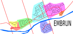
Yellow – Industrial Park
Red – Business Park
Green – Chantal Development
Light Blue – Centre ville (town centre)
Purple – Bourdeau Development in the Embrun-Sud (Embrun South) area
Pink – Lapointe Development and Mélanie Construction
Orange – Maplevale
The smaller community of Brisson may be considered part of Embrun, as it is no longer recognized by any municipal entity.
The municipality has recently adopted smart growth principles to guide its future development. The official plan calls for densification and infill of existing urban land, rather than acquiring more rural land. A near-doubling of Embrun’s population will be accomplished in the next 10–15 years with only two new neighbourhoods (both in land already designated as urban land use zones) being built. The rest of the population growth will be done by building housing units in the open spaces between existing neighbourhoods, and by eventually replacing single-family homes on some busier streets with apartments and condos. Through this plan, Embrun’s population will increase from its current population of around 6,000 people to upwards of 10,000 people in 2021, with only a small amount of land to the west being added to the urban zone.
Business Park
The Embrun Business Park is located in the extreme western part of Embrun, west of the Chantal Development. The area is home to nearly all of the town’s major businesses. In this area is the Place d’Embrun Shopping Centre as well as some of the town’s chain restaurants (e.g., Tim Hortons and Dairy Queen) and large businesses such as renovators, grocery stores and automobile garages. However, this part of Embrun lacks small businesses. Most of the small businesses are in other parts of Embrun.
This part of Embrun, however, has almost no permanent residents due to the fact that it is almost exclusively commercial. There are a few people living on Notre-Dame Street in this area, however, these people are counted as part of the Chantal Development in population counts. The area is paved with many asphalt service roads crisscrossing the area.
Industrial Park
Embrun also has an Industrial Park. Despite the name, the Industrial Park doesn’t really have any industry, just semi-industrial commerce such as warehouses. The Ontario Provincial Police Station is also located here. The Industrial Park is located just to the north of the Embrun Business Park.
The Industrial Park is one of the westernmost areas of Embrun. It has three streets: Industrial Street, New York Central Avenue, and Bay Street.
As a result of municipal zoning regulation reform undertaken in 2010, the Industrial Park technically no longer exists, as the old commercial & industrial zones were replaced with a new “Business Park” designation. Nonetheless the two areas are distinct in the types of enterprises operating in them.
Chantal Development
Chantal Development is a rather quiet residential area in the Western part of Embrun. To the east of Chantal Development lies the town centre (officially called Centre-Ville). To the west lies the Business Park and the Industrial Park.
There are several streets in the Chantal Development: Olympic Street, Domaine Street, Menard Street, Isabelle Street, Loiselle Street, Chantal Crescent, Promenade Boulevard, and Chateau Crescent.
An infill subdivision is planned for the area and will be located immediately to the north of the current development.
Town Centre/Centre-Ville
Town Centre/Centre-Ville is home to two of the town’s schools (École Publique de la Rivière Castor and St. Jean/La Croisée). Also, the Église St. Jacques is in this part of town. To the west of Town Centre/Centre-Ville is Chantal Development. To the east is Lapointe Development. To the south is the neighbourhood of Embrun South. To the north is rural areas.
The major streets are Ste. Jeanne d’Arc Street, Blais Street, Centenaire Street (also in Lapointe Development), St Jean Baptiste Street, Castlebeau Street, St. Augustin Street, and Lamadeleine Boulevard.
Some infill has occurred in recent years, and more is planned along the western and northern fringes of the neighbourhood.
Lapointe Development
The Lapointe Development is in the eastern part of Embrun. To the west is Town Centre/Centre-Ville and to the south is the small neighbourhood of Maplevale. To the north is Brisson. The Lapointe Development is currently undergoing infill expansion. The term Melanie Construction (after the developer who is building the infill projects) refers to the newer infill subdivisions. Another infill subdivision is planned just northwest of the current infill area, and will be integrated into infill projects in the Town Centre/Centre-Ville. In addition, an entirely new neighbourhood (not infill) is also planned to the northeast along St-Thomas Road.
There are several streets in the Lapointe Development: Lapointe Boulevard, Fleurette Street, Sophie Street, Alain Street, Chateauguay Road, Filion Street, La Prairie Street, Centenaire Street (also in Town Centre/Centre-Ville), Frontenac Boulevard, Citadelle Street, Louis Riel Street, La Croisée Street, Radisson Drive, Bourassa Street and Normandie Street.
Embrun South
The area of Embrun south of the Castor River is called Embrun South (Embrun-Sud in French). The area has a housing subdivision, as well as older, mixed development along arterial roads. To the north lies Town Centre/Centre-Ville. To the east, west and south lies rural areas. The area is near the Embrun Water Tower on St-Jacques Road. The land area formerly known as the Norm’s Gym summer camp (condos will replace the camp), as well as the École secondaire catholique Embrun are in this area. No infill developments have taken place, although a completely new neighbourhood to the east of the current development, along St-Joseph Road, is planned.
Maplevale
The small neighbourhood of Maplevale, located to the immediate south of the Lapointe Development, is a more affluent area with a higher land values and larger homes.
Transportation
The main road in Embrun is Notre-Dame Street (County Road 3). This busy street travels east–west across Embrun, linking its neighbourhoods together. At its western end it connects to Castor Street in neighbouring Russell, while its eastern end travels to the nearby village of Casselman, located 12 km to the east. As Embrun grows, the street has experienced significant congestion. Part of this is aggravated by the fact that, with the exception of a 1 km section in western Embrun which has a centre turning lane, the street is still a conventional two lane street. The municipality has studied the possibility of widening the entire stretch of the street to two lanes in each direction with a centre turning lane, however the cost of this is seen as prohibitive, so instead, the municipality has focused on projects to make traffic flow more efficient. This included the upgrading of intersections, including the installation of new left-turn signals at two intersections (completed in 2011) and the replacement of another intersection with a roundabout (completed in 2012).
Embrun is located 8 km south of Highway 417, a major freeway that links Ottawa and Montreal, and which is part of the Trans-Canada Highway network. Two exits–#88 and #79—provide access to Embrun. St-Guillaume Road links Exit #88 with Notre-Dame Street, while Limoges Road does the same for Exit #79. St-Guillaume Road and Exit #88 is the busier of the two, because it is significantly closer to Ottawa. Embrun’s rapid growth in recent years as well as an increased trend of commuting to Ottawa for work has led to congestion on St-Guillaume Road. A study by the county council proposed widening St-Guillaume Road into a four-lane road, or introducing a new corridor to the highway in between exits #88 and #79.
Embrun also has a small bike lane network. A bicycle route runs east–west through the community. This route consists of a bike trail in the western part of the community, a bike lane on Blais Street in the centre, and a bike lane on Centenaire Street in the east.
A privately operated airfield, the Ottawa/Embrun Aerodrome is located to the southwest of the urban area of Embrun.
Public transit
Township of Russell Transit Service
In recent years, transit service has been introduced to the community. The municipal government, through a contract with Trillium Coach Lines, runs three peak-hour express routes to downtown Ottawa from Embrun. They are:
Route 523, which arrives in Ottawa for 7am and leaves Ottawa a little after 3pm.
Route 524, which arrives in Ottawa for 7:30am and leaves Ottawa at 4pm
Route 525, which arrives in Ottawa for 7:50am and leaves Ottawa at 4:15pm
As this route is contracted with a private company, fares are high. A monthly pass costs $232, while one-way cash fare is $12. Because of this, some Embrun residents instead take OC Transpo route #232, which has a stop at a park and ride lot 8 km north of Embrun. This is considerably cheaper (Route #232 costs $119 for a monthly pass and $4.65 for one-way), but less convenient, as OC Transpo does not service the community itself, meaning Embrun residents have to drive 8 km to the park and ride lot to ride OC Transpo. Route 232 also has later scheduled times—the latest trip on the 232 arrives in Ottawa for 8:20am, and leaves Ottawa at 5:15pm, which is much more convenient for Embrun residents who work 9-5 workweeks.[/fusion_text][/fusion_builder_column][fusion_builder_column type=”1_1″ layout=”1_1″ spacing=”” center_content=”no” link=”” target=”_self” min_height=”” hide_on_mobile=”small-visibility,medium-visibility,large-visibility” class=”team-column” id=”6″ background_image_id=”” hover_type=”none” border_size=”0″ border_color=”” border_style=”solid” border_position=”all” border_radius_top_left=”” border_radius_top_right=”” border_radius_bottom_right=”” border_radius_bottom_left=”” box_shadow=”no” box_shadow_vertical=”” box_shadow_horizontal=”” box_shadow_blur=”0″ box_shadow_spread=”0″ box_shadow_color=”” box_shadow_style=”” padding_top=”” padding_right=”” padding_bottom=”” padding_left=”” margin_top=”” margin_bottom=”60px” background_type=”single” gradient_start_color=”” gradient_end_color=”” gradient_start_position=”0″ gradient_end_position=”100″ gradient_type=”linear” radial_direction=”center center” linear_angle=”180″ background_color=”” background_image=”” background_position=”left top” background_repeat=”no-repeat” background_blend_mode=”none” animation_type=”” animation_direction=”left” animation_speed=”0.3″ animation_offset=”” filter_type=”regular” filter_hue=”0″ filter_saturation=”100″ filter_brightness=”100″ filter_contrast=”100″ filter_invert=”0″ filter_sepia=”0″ filter_opacity=”100″ filter_blur=”0″ filter_hue_hover=”0″ filter_saturation_hover=”100″ filter_brightness_hover=”100″ filter_contrast_hover=”100″ filter_invert_hover=”0″ filter_sepia_hover=”0″ filter_opacity_hover=”100″ filter_blur_hover=”0″ last=”no”][fusion_text columns=”” column_min_width=”” column_spacing=”” rule_style=”default” rule_size=”” rule_color=”” hide_on_mobile=”small-visibility,medium-visibility,large-visibility” class=”” id=”” animation_type=”” animation_direction=”left” animation_speed=”0.3″ animation_offset=””]
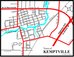
Kemptville
Kemptville is a community located in the Municipality of North Grenville in Southern (Eastern) Ontario in the northernmost part of the United Counties of Leeds and Grenville. It is located approximately 56 km south of Ottawa and 2.5 to 3 km south of the Rideau River.
The community can be accessed by way of the former Highway 16 and Leeds and Grenville Road 43, the former Highway 43, which links Perth and former [Highway 34 (Ontario)Alexandria]. It is now accessed by Highway 416, also known as the Veterans Memorial Highway, which was completed in 1999, via an interchange to the east on the old road to Alexandria.
Kemptville is the largest community in North Grenville, holding about 23% of North Grenville’s population. Four elementary schools are located in the two – Oxford-on-Rideau Public School, Holy Cross Catholic School, Kemptville Public School and South Branch Elementary School -, two high schools – North Grenville District High School and St. Michael Catholic High School -, three parks, and two hotels.
The residential area is generally located in the south and east parts of the community.The main streets are Rideau, Prescott, Clothier and Van Buren streets. A creek named Kemptville Creek divides Kemptville in the southeast, where the least part of Kemptville is found. The creek begins southwest of Kemptville and empties 4 km NE into the Rideau River. Much of Kemptville is forested, especially east and north of the community. Farmland covers the rest of the area, especially the west and the southern part of the community, with some exceptions. There are some homes lying next to the farmland.
History of Kemptville
The small town of Kemptville began to emerge from the forest in the township of Oxford when Lyman Clothier, a resident of New England, bought 100 acres (0.40 km2) of land from a John Byce, for the price of a yoke of oxen, and a fusee (i.e. here, a flintlock rifle). Mr. Clothier had lived in the general area since 1804 or 1805, and in 1812 he made the afore-mentioned transaction with Mr. Byce, to establish a lumber mill. Mr. Clothier began construction of a saw mill with the assistance of his 4 sons, and they built two dwellings in what is now present-day Kemptville. This mill was extremely important for the settling of the community, as in order to construct a crude dwelling, lumber was required – and so, the mill began to facilitate the construction of dwellings for settlers all over Oxford Township.
The village location chosen by Mr. Clothier was a location that became a point on the Ottawa – Prescott road. As a result, and as a direct consequence of the many travellers passing through the settlement, one of Mr. Clothier’s sons, Asa, made a habit of opening his home to these travellers as a resting place and as a meeting place. Thus, the “Clothier’s Hotel” was born. The next major industry to be established was that of a grist mill in 1821, when the Clothiers placed some grinding stones in the lower part of their saw mill. As a result of this, rather than taking their grain to a site on the St. Lawrence River, which would be a daunting hike in the best of conditions, or grinding the grain in an extremely ineffective and crude fashion, the settlers could now take it to this grist mill. After this was established, a blacksmith’s shop was established, run also by the Clothiers. A schoolhouse was established in 1823, which served the surrounding communities for many years. The first physician arrived in the community the year after the school was established.
The small village was fast expanding – and the residents of the region were beginning to think about officially giving a dignified name to the location in which they lived. Initially, the community was known as “The Branch”, and later, for obvious reasons, “Clothier’s Mill”. So, during a public meeting at this time, the name “Kemptville” was suggested, to honour Sir James Kempt, the Governor General of Upper Canada in 1828 who was said to have camped on the banks of the Rideau River near the settlement. The name was adopted in the late 1820s and the first map with the name “Kemptville” was produced in 1830.
A weekly newspaper is published in Kemptville, called the Kemptville Advance, and has been published since 1855. The Kemptville Advance celebrated its 150th anniversary in 2005.
History of Kemptville
The following is a section of the Kemptville Weekender, printed for the 150th anniversary of Kemptville. Written by Drew Headrick.
Oxford-On-Rideau was first surveyed in 1791, incorporated in 1850. It includes the following communities: Acton’s Corners, Bedell (Kempton), Bishop’s Mills, Beckett’s Landing, Burritt’s Rapids, Christies Corners, East Oxford, Kemptville (inc. 1857), Millar’s Corners, Newmanville, Oxford Mills, Oxford Station, Patterson’s Corners, Swan Station. This is the first known complete survey of this and the surrounding area by the government of England.
The original owner of the land encompassing Kemptville was John Byce. Lyman Clothier was the man who purchased 100 acres (0.40 km2) from Mr. Byce for “a yoke of oxen and a fusee” which in today’s terms would mean a pair of oxen and a flintlock rifle (approximate cost at that time was $14.00). Mr. Clothier would make the greatest impact for growth in the area by setting up a saw mill and later a grist mill.
Lyman Clothier was born in 1762 in Connecticut and moved to Canada around 1804-05 even though his family was still living in upstate New York. Around 1814 the purchase of the land around Kemptville went through and the chore of building a dam to harness the power of the Kemptville Creek (actual name was changed to the South Branch of the Rideau River) began so that a saw mill could be built. The saw mill was opened around 1815 and followed by a grist mill in 1817; these two factors allowed the area to expand and grow as people didn’t have to travel out of the area to get lumber and have their grain milled.
In 1819, Asa Clothier (Lyman’s son) opened the first hotel in the area which soon became a welcome stop on the highway between Ottawa and Prescott. The first schoolhouse was built in 1820 and would serve for 23 years until Anthony House was built and opened in 1843-4.
The name Kemptville was adopted in 1829 as a tribute to Sir James Kempt who was the Governor of British North America and was appointed to review changes to the Rideau Canal and toured this area in 1828. It is rumoured that he did spend and overnight in this area. Before the name change this area was known as The Branch and Clothier Mills after the mill that was located in the little town. Population of Kemptville around 1829 was 125 people and was substantial considering that the population 14 years earlier was just one family: the Clothiers.
By 1830 Kemptville had all the amenities that a rural farming community needed in Ontario and was soon a centre for the whole area to shop and trade goods. There was a school, a doctor, two blacksmiths, a general store, a wagon shop, and a hotel.
Lyman Clothier Sr. died in 1839 at the age of 77. He fathered 15 children and founded this great “little” town. He was buried at St. James Anglican Church on Clothier Street almost opposite the house that his son, Lyman Jr. built in 1842.
Sir James Kempt
The following is a section of the Kemptville Weekender, printed for the 150th anniversary of Kemptville. Written by Drew Headrick.
Born in Scotland 1765 and died in London 1854.
Kempt was a career soldier who was chosen to head up a committee of military engineers appointed in 1827 to look into proposed changes for the Rideau Canal. Kempt toured the Rideau in the spring of 1828, and quite possibly did camp near the town of Kemptville, making recommendations in June, 1828 that the lock side be increased from 108 x 20 to 130x 33.
He was appointed Governor of British North America in 1828 and held the post for only two years. He was well liked and respected throughout Canada.
Businesses
The following is a section of the Kemptville Weekender, printed for the 150th anniversary of Kemptville. Written by Drew Headrick.
From 1830 to 1857 Kemptville would see expansion in its business base that would be rivaled by any growing small community in Canada. Already established were the basics required to draw people to the area to trade and barter, but it was the potential for success in this area that would lure new businesses to set up shop and move here with their families.
This is a listing of the businesses that we know existed in Kemptville at this time though there are doubtless more that were within the vicinity. The list is only as accurate as records can establish. It is interesting to note most establishments were located north of the Kemptville Creek and that the southern half was referred to as “across the river” or “that hole in the woods.” In fact, Asa Street was the last real street in Kemptville, as beyond that was pure pasture and farmland.
As you can well imagine, with the arrival of steamships at Beckett’s Landing and Kemptville itself, trade routes allowed the town to flourish and prosper. It would do so even more when in 1854 the first train would arrive linking Kemptville with Ottawa, Prescott, and the world.
Between 1830 and 1857 the following businesses were established in Kemptville:
4 tailors
5 carpenters/builders
2 shoemakers
2 saw mills
3 grain mills
4 carriage makers
4 blacksmiths
2 brewers/distillers (at least)
4 hotels
1 painter
3 carding mills
1 private banker
2 tinsmiths/coppersmiths
2 furniture makers
2 saddle/harness makers
3 cabinet makers and furniture dealers
3 doctors (1 specialized in natural remedies)
3 tanners/harness makers/shoemakers
3 barrel makers
7 dry goods merchants
Churches
The following is a section of the Kemptville Weekender, printed for the 150th anniversary of Kemptville. Written by Drew Headrick.
Three churches with actual buildings were located within Kemptville before 1850. Some have been remodeled and some completely rebuilt and a few have even moved from their original location. Churches were perhaps as important in rural Canada in those days as having a general store and a hotel in the community since most people of the day did attend the church of their faith. Today most of the churches are still around with many more choices than back in the early 1800s yet they are still important when reviewing the history of the area and even the architecture.
The Anglican church on Clothier Street West and Harriet Street is the earliest in the area opened in 1829 and updated in the late 1870s. The Methodist church, was located at Clothier and Lydia street (the cemetery is one of the few reminders of the old church and can still be seen at the entrance to Curry Park). Holy Cross Catholic church was first erected in mid 1833 consisting of a small stone structure, enough to allow for services until the new church would be built some 56 years later. It too is located on Clothier Street West with quarters built next door to house the priests and visiting guests.
In 1847 the Baptist church was built uniting two congregations: Kemptville and Pelton’s Corners. In 1851 the Presbyterian church was built on Prescott Street after being housed in many different locations in and outside of Kemptville. Many churches are within the area yet at the same time they were all considered part of the Kemptville area drawing from the townspeople and the surrounding countryside.
The railroad
The following is a section of the Kemptville Weekender, printed for the 150th anniversary of Kemptville.
The first railroad in the history of Ottawa was started in 1850 with the forming of the Bytown and Prescott Railway Corporation which would build and run the rail line between the two towns. It would take over four years to reach Kemptville but would play an important role in unifying the soon to be Nation’s Capital with the rest of Upper Canada and the United States. By August 9, 1854, the track has reached Kemptville from Prescott and the first regular service started in the week of Christmas that same year. Return trip to and from Ottawa (or Prescott) was $2.00. The opening of this line was one reason as to the formation of the Village of Kemptville as the township of Oxford-On-Rideau had given money for the building of this line and the people of the village thought they might escape their portion of the financial commitment. They also wanted more control over political and social matters believing that their population was enough to warrant the granting of the title “Village.” Three years after the arrival of the railroad, they would get the distinction “village” but would retain their financial obligation – the days of moving freight and people by ship were numbered.
The Holiness Movement – Free Methodist Church The Holiness Movement Church (now Free Methodist) in Kemptville was officially formed in 1902 and soon afterward opened a white frame church on Thomas Street near the corner of Asa.
Sports
The Kemptville 73’s are a Tier II Junior “A” ice hockey team and members of the Central Junior A Hockey League. The team was founded as the Kemptville Comets of the Rideau-St. Lawrence Junior B Hockey League in 1969, but the league later became the Eastern Ontario Junior B Hockey League and the Comets became the 73’s in 1973. The 73’s were promoted to Junior “A” in the Summer of 2007.
Birthplace of 1930’s NHL player Desse (Desmond) Roche.
Nearest settlements
Beckett’s Landing, N of the Rideau River
Sabourins Crossing, NE
Actons Corners, W
Nearest towns
Bishop’s Mills, Ontario
[/fusion_text][/fusion_builder_column][fusion_builder_column type=”1_1″ layout=”1_1″ spacing=”” center_content=”no” link=”” target=”_self” min_height=”” hide_on_mobile=”small-visibility,medium-visibility,large-visibility” class=”team-column” id=”7″ background_image_id=”” hover_type=”none” border_size=”0″ border_color=”” border_style=”solid” border_position=”all” border_radius_top_left=”” border_radius_top_right=”” border_radius_bottom_right=”” border_radius_bottom_left=”” box_shadow=”no” box_shadow_vertical=”” box_shadow_horizontal=”” box_shadow_blur=”0″ box_shadow_spread=”0″ box_shadow_color=”” box_shadow_style=”” padding_top=”” padding_right=”” padding_bottom=”” padding_left=”” margin_top=”” margin_bottom=”60px” background_type=”single” gradient_start_color=”” gradient_end_color=”” gradient_start_position=”0″ gradient_end_position=”100″ gradient_type=”linear” radial_direction=”center center” linear_angle=”180″ background_color=”” background_image=”” background_position=”left top” background_repeat=”no-repeat” background_blend_mode=”none” animation_type=”” animation_direction=”left” animation_speed=”0.3″ animation_offset=”” filter_type=”regular” filter_hue=”0″ filter_saturation=”100″ filter_brightness=”100″ filter_contrast=”100″ filter_invert=”0″ filter_sepia=”0″ filter_opacity=”100″ filter_blur=”0″ filter_hue_hover=”0″ filter_saturation_hover=”100″ filter_brightness_hover=”100″ filter_contrast_hover=”100″ filter_invert_hover=”0″ filter_sepia_hover=”0″ filter_opacity_hover=”100″ filter_blur_hover=”0″ last=”no”][fusion_text columns=”” column_min_width=”” column_spacing=”” rule_style=”default” rule_size=”” rule_color=”” hide_on_mobile=”small-visibility,medium-visibility,large-visibility” class=”” id=”” animation_type=”” animation_direction=”left” animation_speed=”0.3″ animation_offset=””]
Perth
Perth is a town in Eastern Ontario. It is located on the Tay River, 83 kilometres (52 mi) southwest of Ottawa, and is the seat of Lanark County.
History
The town was established as a military settlement in 1816, shortly after the War of 1812. The settlement of Lanark County began in 1815. In that year “the Settlement forming on the Rideau River” as it was officially referred to (and which soon became known as “Perth Military Settlement”) began to function under Military direction. Several townships were surveyed to facilitate the location of farms for military and other settlers; and the site of the future Town of Perth, which had been chosen as the headquarters of the Military Establishment was surveyed in 1816.
Many of the first settlers were military veterans on half pay, while others were military veterans from France, Germany, Poland, Italy, Scotland or Ireland who were offered land in return for their service. The Rev. William Bell, who arrived in June 1817, noted in his diaries that the settlement was more European than the Scottish settlement described to him. The first Scottish settlers came in 1816. Many of the Scottish immigrants were stonemasons; their work can be seen in many area buildings and in the locks of the Rideau Canal.
The military regime lasted until 1824, when settlers were granted municipal rights, i.e., ‘the right of self government’. For many years Perth was the military, judicial, political and social capital, not only of the County of Lanark, but of the whole of the Ottawa Valley, north and west, until owing to the construction of the Rideau Canal, and the development of the lumber industry further north and west along the Ottawa, it finally was eclipsed by the town called “Bytown”—the present City of Ottawa, the Capital of the Dominion. But for many years the people of the town of Bytown, while it was still ‘Bytown’ had to come to Perth for their law and justice, for the law courts of the whole great district were located there.
The first secretary/stores-keeper (and eventually postmaster and superintendent) of the settlement was Daniel Daverne, brought up from the Quarter Masters General Department in Kingston, Ontario to assume these positions.
Perth is home to Canada’s oldest pioneer burial ground, St. Paul’s United Church Cemetery, formerly The Old Methodist Burying Ground. This cemetery is at the south-east end of the Last Duel Park on Robinson Street. The Craig Street Cemetery, sometimes referred to as the “Old Burying Grounds” also contains many historic graves and saw use from 1820–1873.
The town’s motto is “Pro Rege, Lege et Grege” (“For the King, the Law and the People”) which was adopted in 1980 along with a new crest. The previous motto, “Festina lente sed certo” (“Make haste slowly but surely”), and original town crest appears on the uniforms of the Perth Citizen’s Band. Founded in 1850, this band continues a tradition of community music with numerous concerts each season.
Near the town is the home of world show jumping champion Ian Millar and Millar Brooke Farm where his great horse Big Ben (1976–1999) is buried. The town has erected a bronze life-sized statue of the horse and Ian Millar, in John A. Stewart Park, across from the Code’s Mill building.
This town was the site of the last fatal duel in Upper Canada. Robert Lyon, a law student, was killed on June 13, 1833 after fighting over a woman (Elizabeth Hughes) with a former friend, John Wilson.
Perth is also the site of the first installation of a telephone other than Bell’s experimental installations. A town dentist, Dr. J. F. Kennedy, a friend of Alexander Graham Bell, installed a direct telephone connection between his home and office. By 1887, there were 19 telephones in Perth, with a switchboard in Dr. Kennedy’s office.
In 2010 Perth held the historic “Kilt Run” in which 1067 kilt-clad runners crossed the finish line. The idea to hold a kilt run in Perth, Ontario was conceived in October 2009 by Terry Stewart after the Mayor of Perth, Ontario submitted a letter to the Perth Courier requesting town residents to come up with an idea to help Perth, Scotland celebrate their 800th Anniversary. It has become an annual event. The 2016 Kilt Run attracted 5,000 runners as part of the town’s 200th anniversary.
In 1893 a 22,000 pound cheese known as the ‘Mammoth Cheese’ was produced in Perth to be exhibited in Chicago at the World’s Columbian Exposition to promote Canadian cheese around the world.
Sites and attractions
The heritage downtown core of today’s Perth consists of boutiques, specialty shops and restaurants, including crafts, antiques and flea market, and summer Farmers’ and Craft Markets. Most of these operate out of the century-old stone buildings in town. The Links O’Tay Golf course, walking distance from the downtown core, began its trek through golfing history in 1890 and is now Canada’s oldest continuously operating golf course. The Perth Citizens Band, still giving concerts on the band stand behind City Hall, is a tradition dating back over 150 years. The band is Canada’s oldest active town band. The Perth Citizens Band played “The Maple Leaf Forever” as the Mammoth Cheese departed to the Chicago World’s Fair in 1893. The bandstand has been behind the Town Hall since it was moved there in 1901 and free summer concerts have taken place there ever since.
An interesting feature of the downtown core is the Crystal Palace, constructed from the discarded remnants of the glass street enclosures that used to be on Rideau Street in nearby Ottawa. This structure houses the Perth Farmers’ and Craft Markets on summer Saturdays.
The Tay River splits into two main channels for much of its course through Perth. Much of downtown Perth, including the town hall, is on the island formed by the two channels. During the summer and fall of 2015, the fork in the river was modified to reduce erosion and flooding downstream in town.
Sports
Hockey is very popular in Perth as it has been home to senior and junior teams. Currently, Perth is represented by the Blue Wings in the Eastern Ontario Junior “B” Hockey League. Perth was home to a professional baseball team for two years (1936–37) as part of the Canadian–American League.
Both high schools in Perth also offer a variety of other sports, such as basketball, football, soccer and track.
Schools
Queen Elizabeth Elementary School
Stewart Elementary School
Perth District Collegiate Institute
St. John Elementary School
St. John Catholic High School
Algonquin College Heritage Institute
Montessori School
Notable people from Perth
-Alexander Morris, Canadian politician and second Lieutenant-Governor of Manitoba and the North-West Territories (1872–1878)
-Herbert Taylor Reade, an assistant surgeon with the 61st Regiment, he was awarded the Victoria Cross for his gallantry in the siege of Delhi in 1857.
-William Richard Motherwell, Former Saskatchewan Minister of Agriculture and Federal Minister of Agriculture
-Les Douglas, former NHL player and winner of the Stanley Cup with the Detroit Red Wings.
-Floyd Smith, former NHL player and coach
-Gord Smith, former NHL player
-Billy Smith, Hall of Fame NHL Goaltender
-Ian Millar, prolific show-jumper; equestrian world champion and Olympic silver-medalist
-Mike Brown, Olympian, Swimming
-Sultana Frizell, Olympian Hammerthrower
-Nicholas Tritton, Olympian Judo
-Crispin Lipscomb, Olympian Snowboarding
-Evan Starkman, Reality Television Star
-Jared Coreau, current NHL player
Local media
CHLK-FM Lake 88.1 FM Radio[/fusion_text][/fusion_builder_column][fusion_builder_column type=”1_1″ layout=”1_1″ spacing=”” center_content=”no” link=”” target=”_self” min_height=”” hide_on_mobile=”small-visibility,medium-visibility,large-visibility” class=”team-column” id=”8″ background_image_id=”” hover_type=”none” border_size=”0″ border_color=”” border_style=”solid” border_position=”all” border_radius_top_left=”” border_radius_top_right=”” border_radius_bottom_right=”” border_radius_bottom_left=”” box_shadow=”no” box_shadow_vertical=”” box_shadow_horizontal=”” box_shadow_blur=”0″ box_shadow_spread=”0″ box_shadow_color=”” box_shadow_style=”” padding_top=”” padding_right=”” padding_bottom=”” padding_left=”” margin_top=”” margin_bottom=”60px” background_type=”single” gradient_start_color=”” gradient_end_color=”” gradient_start_position=”0″ gradient_end_position=”100″ gradient_type=”linear” radial_direction=”center center” linear_angle=”180″ background_color=”” background_image=”” background_position=”left top” background_repeat=”no-repeat” background_blend_mode=”none” animation_type=”” animation_direction=”left” animation_speed=”0.3″ animation_offset=”” filter_type=”regular” filter_hue=”0″ filter_saturation=”100″ filter_brightness=”100″ filter_contrast=”100″ filter_invert=”0″ filter_sepia=”0″ filter_opacity=”100″ filter_blur=”0″ filter_hue_hover=”0″ filter_saturation_hover=”100″ filter_brightness_hover=”100″ filter_contrast_hover=”100″ filter_invert_hover=”0″ filter_sepia_hover=”0″ filter_opacity_hover=”100″ filter_blur_hover=”0″ last=”no”][fusion_text columns=”” column_min_width=”” column_spacing=”” rule_style=”default” rule_size=”” rule_color=”” hide_on_mobile=”small-visibility,medium-visibility,large-visibility” class=”” id=”” animation_type=”” animation_direction=”left” animation_speed=”0.3″ animation_offset=””]
Rockland
Rockland is a bilingual community located about 40 kilometres (25 mi) east of downtown Ottawa, part of the city of Clarence-Rockland. Rockland has a population of 11,099.
History
The Clarence region began growing in 1840 with the development of the road to l’Orignal-Bytown. Before then, farmers relentlessly cleared wooded space to be able to cultivate land, their only survival mean. In 1868, a young entrepreneur, William Cameron Edwards, decided to establish a sawmill at the McCaul point. The opening of link to the Grand Trunk Railway followed in 1888 to allow wood and merchandise to be transported. Edwards, who held timber rights in the area and was also the first postmaster, named the area for the rocky nature of its landscape.
In 1889, the mission served by the priest Caron from Clarence-Creek became a parish. The first priest of the new parish was Siméon Hudon, native of Québec City. The first school opened in 1875 while the first high-school opened in 1905.
Construction of a second railroad in 1908 linking Ottawa and Hawkesbury greatly promoted population. In effect, for 75 cents (return) people could go to Ottawa to run errands and return in the same day. The woodmill owned by W. C. Edwards closed its doors in 1926, as a result of the economic turmoil following the First World War. A large part of the population moved to the Quebec province to find employment in the woodmills in Hull and Gatineau. The economic recovery began in 1939 with the start of the Second World War. The return of soldiers after the war brought an increase in population. Construction of homes increased rapidly creating a need for expanded water services, electricity and a sewer system implemented in 1964.
Throughout the 1970s, Rockland was a small community with a population of about 3500 people. Since the turn of the millennium, it has seen rapid growth in housing development. Prior to 2000, new homes built were below 60 or 70 annually, but in the period 2000–2010, the total number of new homes built was 2185.
Commercial expansion
Rockland is a rapidly growing community, and is constantly adding new retailers and businesses to service the community.
Rockland has local outlets of major chains like A&W Restaurant, Boston Pizza, Tim Hortons, Canadian Tire, Subway Restaurant, Dollarama, Food Basics, EB Games, Giant Tiger, Home Hardware, Independent Grocers, LCBO, McDonald’s Restaurant, Mark’s Work Wearhouse, 2Networkit.com Inc., Shoppers Drug Mart, SonXPlus, Roch Drouin Auto Repair, St-Hubert Express Restaurant, Gabriel’s Pizza, POP Shoes, RE/Max Riviera 2000 Realty Inc., Brokerage, TSC and Walmart Supercentre.
In addition to the many local restaurants, Rockland has the River Rock Inn, a hotel and conference centre.
Leisure
Rockland is home to a newly constructed 45,000-square-foot (4,200 m2) Recreation Centre. The centre houses the Rockland Library, the largest YMCA in the Ottawa area (with indoor swimming pool, state-of-the-art gymnasium, numerous children’s/youth/family/senior programs) and theatre.
On July 8, 2009, the Canadian and Ontario governments jointly announced funding for the construction of a new sporting event and training center in Rockland. The Centre will help meet the sports and recreational needs of the City of Clarence-Rockland and Eastern Ontario by providing two NHL-size ice surfaces, two soccer fields, a baseball diamond and a running track, as well as enhance the level of recreational tourism in the region. The multi-use facility will also allow for the creation of an advanced hockey program for secondary-school level hockey players and used as a national training facility for Hockey Canada.
The semi-private Outaouais Golf Club has courses that are considered among the highest rated in the National Capital Region. CPGA professionals are onsite to provide lessons, and practice sessions are also available to all golfers.
Education
There are a variety of schools in Rockland including Anglophone public, Francophone public, Anglophone Catholic, and Francophone Catholic.
Elementary
Rockland Public School (RKPS)
St. Patrick Catholic Elementary School
École élémentaire catholique Sainte-Trinité
École Carrefour Jeunesse
High school
École secondaire catholique L’Escale
Rockland District High School (RDHS)
St. Francis Xavier Catholic High School (St. FX) located in Hammond but attended by many students from Rockland
Canadian International Hockey Academy
Adult
Eastern Ontario Education and Training Centre
Music
Rockland Music School
Domenic’s Academy of Music
Transportation
The community is served by Prescott-Russell Road 17, a two-lane road that by-passes the centre of the community to its north, though multiple businesses including big-box stores have been built along the roadway over the past several years. Heading west, it becomes Ottawa Road 174 heading towards Orleans and downtown Ottawa via Highway 417. Eastward it connects to municipalities such as Wendover, Alfred, Plantagenet and Hawkesbury. Prior to the downloading of multiple roads across the province by the Mike Harris government during the 1990s, it was known as Ontario Highway 17 east of the Highway 417 and 174 split. During the past several years, there have been calls to widen Highway 174 between Trim Road and Rockland though the city of Ottawa had previously refused funding for the highway though some Ottawa councillors as well as the federal government have expressed support for the widen due to safety reasons and multiple fatal crashes.
The community is also served by a commuter bus line operated by Leduc Bus Lines which offers 10–12 trips from the village to downtown Ottawa and Gatineau during rush hour.
The community of Rockland wishes to establish OC transportation connections by the end of 2015 in hopes of exchanging Ottawa city culture with the rural French community that inhabits Rockland.[/fusion_text][/fusion_builder_column][fusion_builder_column type=”1_1″ layout=”1_1″ spacing=”” center_content=”no” link=”” target=”_self” min_height=”” hide_on_mobile=”small-visibility,medium-visibility,large-visibility” class=”team-column” id=”9″ background_image_id=”” hover_type=”none” border_size=”0″ border_color=”” border_style=”solid” border_position=”all” border_radius_top_left=”” border_radius_top_right=”” border_radius_bottom_right=”” border_radius_bottom_left=”” box_shadow=”no” box_shadow_vertical=”” box_shadow_horizontal=”” box_shadow_blur=”0″ box_shadow_spread=”0″ box_shadow_color=”” box_shadow_style=”” padding_top=”” padding_right=”” padding_bottom=”” padding_left=”” margin_top=”” margin_bottom=”60px” background_type=”single” gradient_start_color=”” gradient_end_color=”” gradient_start_position=”0″ gradient_end_position=”100″ gradient_type=”linear” radial_direction=”center center” linear_angle=”180″ background_color=”” background_image=”” background_position=”left top” background_repeat=”no-repeat” background_blend_mode=”none” animation_type=”” animation_direction=”left” animation_speed=”0.3″ animation_offset=”” filter_type=”regular” filter_hue=”0″ filter_saturation=”100″ filter_brightness=”100″ filter_contrast=”100″ filter_invert=”0″ filter_sepia=”0″ filter_opacity=”100″ filter_blur=”0″ filter_hue_hover=”0″ filter_saturation_hover=”100″ filter_brightness_hover=”100″ filter_contrast_hover=”100″ filter_invert_hover=”0″ filter_sepia_hover=”0″ filter_opacity_hover=”100″ filter_blur_hover=”0″ last=”no”][fusion_text columns=”” column_min_width=”” column_spacing=”” rule_style=”default” rule_size=”” rule_color=”” hide_on_mobile=”small-visibility,medium-visibility,large-visibility” class=”” id=”” animation_type=”” animation_direction=”left” animation_speed=”0.3″ animation_offset=””]
Russell
The Village of Russell is part of Russell Township which in turn is located in the United Counties of Prescott and Russell which covers part of Eastern Ontario. It is located immediately east of Ottawa, the city limits of which are just over 2km west of Russell. Ottawa’s downtown core is about 40km (25mi) northwest of Russell.
The 2006 Census states that the community had a population of 3,540, making it the second largest community in the township of Russell (Russell’s neighbour to the east, Embrun, is the largest community in Russell Township). The vast majority of its residents work in the city of Ottawa, making Russell a true bedroom community for commuters to Ottawa. Agriculture is the main industry in and immediately around the village.
The town produces a large number of hockey prospects for development leagues such as the OHL, OJHL, and NCJHL. The most notable contributions are to the Embrun Panthers Jr. C hockey team.
The town has a significant number of schools – English Catholic Elementary and Secondary, English Public Elementary and Secondary (Russell High School) and French Elementary school (École Saint-Joseph).
Russell also has a summer swimming pool, a skating arena, a library, an All-weather running track and a curling rink. The village also has its firehall on the south end. Russell is policed by the Ontario Provincial Police (OPP). The Russell Watch Program is a community watch where volunteers patrol the village as a second set of eyes and ears for the OPP. Patrols are mostly made during the evening and into the late night. Commercial, recreational, and residential areas are all monitored frequently after dusk.
The village has practicing lawyers, doctors, dentists and other professionals. It also has grocery store, pharmacy, garage, restaurants and many little shops.
The Castor River (translated from French means “Beaver”) runs through the town in summer and offers a flat trail for snowmobiles during the winter.
The village has now passed a local bylaw requiring all commercial signage to be bilingual. This bylaw is being challenged by many, in one case in court.
Russell is a predominantly English-speaking community, although with a sizeable French-speaking minority. 87% of the community speaks English at home, while 11% speak French at home.
The travel time to the nearest built-up areas of Ottawa is typically 20–25 minutes. In the rush hour it can take up to one hour to reach downtown Ottawa, and much more to reach Ottawa boroughs west of the core zone.
In terms of ethnic origin, the people of Russell are mainly of Anglo-Celtic descent, although there are significant populations of Dutch, French, and German descent.[/fusion_text][/fusion_builder_column][fusion_builder_column type=”1_1″ layout=”1_1″ spacing=”” center_content=”no” link=”” target=”_self” min_height=”” hide_on_mobile=”small-visibility,medium-visibility,large-visibility” class=”team-column” id=”10″ background_image_id=”” hover_type=”none” border_size=”0″ border_color=”” border_style=”solid” border_position=”all” border_radius_top_left=”” border_radius_top_right=”” border_radius_bottom_right=”” border_radius_bottom_left=”” box_shadow=”no” box_shadow_vertical=”” box_shadow_horizontal=”” box_shadow_blur=”0″ box_shadow_spread=”0″ box_shadow_color=”” box_shadow_style=”” padding_top=”” padding_right=”” padding_bottom=”” padding_left=”” margin_top=”” margin_bottom=”60px” background_type=”single” gradient_start_color=”” gradient_end_color=”” gradient_start_position=”0″ gradient_end_position=”100″ gradient_type=”linear” radial_direction=”center center” linear_angle=”180″ background_color=”” background_image=”” background_position=”left top” background_repeat=”no-repeat” background_blend_mode=”none” animation_type=”” animation_direction=”left” animation_speed=”0.3″ animation_offset=”” filter_type=”regular” filter_hue=”0″ filter_saturation=”100″ filter_brightness=”100″ filter_contrast=”100″ filter_invert=”0″ filter_sepia=”0″ filter_opacity=”100″ filter_blur=”0″ filter_hue_hover=”0″ filter_saturation_hover=”100″ filter_brightness_hover=”100″ filter_contrast_hover=”100″ filter_invert_hover=”0″ filter_sepia_hover=”0″ filter_opacity_hover=”100″ filter_blur_hover=”0″ last=”no”][fusion_text columns=”” column_min_width=”” column_spacing=”” rule_style=”default” rule_size=”” rule_color=”” hide_on_mobile=”small-visibility,medium-visibility,large-visibility” class=”” id=”” animation_type=”” animation_direction=”left” animation_speed=”0.3″ animation_offset=””]
Smiths Falls
Smiths Falls is a town in Eastern Ontario, with a population of 8,978 according to the 2011 census. It is in the Census Division for Lanark County, but is separated from the county. The Rideau Canal waterway passes through the town, with four separate locks in three locations and a combined lift of over 15 metres (50 ft).
The town’s name was sometimes alternatively spelled “Smith’s Falls” or “Smith Falls”, but “Smiths Falls” is now considered correct.
History
Early history
The city is named after Thomas Smyth, a United Empire Loyalist who in 1786 was granted 400 acres (1.6 km2) in what is present-day Smiths Falls. The Heritage House Museum (c. 1862), also known as the Ward House, was designated under the Ontario Heritage Act in 1977.
Building of the Rideau Canal
At the time of construction of the Rideau Canal a small settlement had been established around a mill operated by Abel Russell Ward, who had bought Smyth’s land. Colonel By ordered the removal of Ward’s mill to make way for the canal. He settled with Ward for £1,500, one of the largest claims made by mill owners on the canal.
The disruption of industry caused by the building of the canal was only temporary, and Smiths Falls grew rapidly following construction. An article in Smith’s Gazetteer in 1846 described the town as a “flourishing little village pleasantly situated on the Rideau River and on the Canal, fourteen miles (21 km) from Perth. It contains about 700 inhabitants. There are fifty dwellings, two grist mills (one with four run of stones), two sawmills, one carding and fulling mill, seven stores, six groceries, one axe factory, six blacksmiths, two wheelwrights, one cabinet maker, one chair-maker, three carpenters, one gunsmith, eleven shoemakers, seven tailors, one tinsmith and two taverns.”
A 36-foot (11 m) drop in less than a quarter of a mile posed an obstacle to navigation at Smiths Falls. A natural depression to the south of the river was used to create a flight of three locks, known as Combined Lockstation today. The natural course of the river was dammed to create a basin upstream of the locks. At the upper end of the basin a fourth (detached) lock was constructed.
A mile below the Combined Lockstation is a flight of two locks called the Old Slys Lockstation. This station is named for the original settler at this location, William Sly. A dam and waste weir control water levels upstream of the locks.
Defensible lockmasters’ houses were built at all three stations in Smiths Falls. The house at Old Slys was built in 1838 and the houses at Combined and Detached around 1842. Only the house at Combined has a second storey, which was added late in the 19th century. The defensible lockmaster’s house at Detached Lockstation was torn down in 1894.
Entry of the railways
In the 1850s the major railway companies were looking to build main trunk lines linking Toronto, Kingston and Montreal. The two major companies at the time, the Canadian Pacific Railway and the Grand Trunk Railway, were competing for the easiest routes to lay track. At one point a fledgling third national railway, the Canadian Northern Railway (CNoR), was also trying to squeeze itself into the busy Montréal-Ottawa-Toronto corridor.
For a number of geographical reasons, and also due to the proximity of the Rideau Canal, the town of Smiths Falls became a major focal point for both the CPR and the CNoR. Each used a mix of existing regional rail lines and new construction to build their networks. CP purchased the 1859-era Brockville and Ottawa Railway, a line from Brockville-Smiths Falls-Sand Point/Arnprior with a branch Smiths Falls-Perth (the latter joining CP’s Ontario and Quebec Railway line to Toronto). CNoR built a 1914-era main line from Ottawa-Smiths Falls-Sydenham (to join an existing Bay of Quinte Railway line extending westward via Napanee-Deseronto[3]). By 1887, the CPR had extended its Toronto-Smiths Falls mainline to reach Montréal; in 1924, 1600 CPR workers were employed in Smiths Falls. This gave the town direct rail lines in half a dozen directions (Toronto, Ottawa, Montréal, Brockville, Napanee and Arnprior) on two different rail companies.
During World War II, Axis prisoners of war (POWs) were transported to Canadian POW camps via the railway. It was near Smiths Falls that German soldier Oberleutnant Franz von Werra jumped from a POW train and escaped to the United States, eventually reaching his homeland. Von Werra was, reputedly, the only escaped Axis POW to successfully return home during the war and his story was told in the book and film entitled The One That Got Away. The North American première of the film occurred on Thursday, 6 March 1958 at the Soper Theatre in Smiths Falls.
Both the Canadian Pacific and the Canadian Northern (later part of Canadian National) had established stations in the town, however, with the creation of Via Rail, the CN station was abandoned and all passenger traffic routed though the CPR station until a new Smiths Falls railway station opened in 2010. The CN station has been renovated and is now home to the Railway Museum of Eastern Ontario. The railway station, along with the nearby railway bascule bridge, comprise the town’s two National Historic Sites of Canada. The Cataraqui Trail now follows the former CN railbed southwest from Smiths Falls, starting from a parking lot at the end of Ferrara Drive.
Economy
The town is on the Rideau Canal system for recreational boating, and is served by the Smiths Falls-Montague Airport for general aviation. It is also a major railway junction point, and its station receives regular passenger service to Ottawa and Toronto from Via Rail.
Several manufacturers were based in Smiths Falls, perhaps the best-known being the Canadian operation of The Hershey Company (opened in 1963) which closed in December 2008. Hershey announced they will instead open a factory in Mexico where they can have cheaper labour. In late 2006, the plant was temporarily closed due to a case of possible salmonella contamination. Other former large manufacturers include RCA Victor (closed circa 1980), Frost and Wood / Cockshutt and Stanley Tools (2008). In 2014, the former Hershey facility was purchased by medical marijuana company Tweed Marijuana Inc.
The Ontario Provincial Police Eastern Region Communications Centre is also located in Smiths Falls. Its communications operators answer emergency 9-1-1 and administrative phone lines, dispatching OPP officers as required.
Sports and recreation
In 1906, a hockey team from Smiths Falls launched an unsuccessful challenge to win the Stanley Cup. Smiths Falls was home to a professional baseball team, the Smiths Falls Beavers, for one season in 1937. The team was a part of the Canadian–American League.
The town is currently home to the Junior A hockey team Smiths Falls Bears, who play in the Central Canada Hockey League.
Education
Public education in the town is managed by the Upper Canada District School Board, while Catholic education is under the care of the Catholic District School Board of Eastern Ontario. Each operates several elementary schools and one secondary school:
Catholic schools
St. James The Greater Catholic Elementary School
St. Francis de Sales Catholic Elementary School
St. Luke’s Catholic High School (Alternative school)
Public schools
Duncan J. Schoular Public School
Chimo Elementary School
Smiths Falls District Collegiate Institute
Notable people
-Oliver R Avison, doctor, pharmacist and missionary. Creator of Severance Hospital (first hospital in Korea). Creator of Severance Union Medical College. Considered the founder of modern medical knowledge in Korea.
-Terry Carkner, former NHL player
-Brooke Henderson, professional ladies golfer and former world number one ranked female amateur at age 16. Henderson won her first major golf tournament at age 18 at the 2016 LPGA Championship, June 12, 2016.
-Todd Lynn, fashion designer
-Gary McAdam, former NHL player
-Don McKenney, former NHL player
Hospitals
General hospital facilities and services are provided by the Perth and Smiths Falls District Hospital, with a site on Cornelia Street. Also located in Smiths Falls was the Rideau Regional Centre, which provided a residential program for mentally challenged and disabled persons from 1951 until its closure in March 2009.
Local media
Newspapers
The Record-News EMC – weekly newspaper
Smiths Falls This Week – weekly newspaper
Radio stations
FM 92.3 – CJET-FM, adult hits
FM 101.1 – CKBY-FM, country music
Nearest cities
Ottawa – about 75 kilometres (47 mi) north-east
Brockville – about 50 kilometres (31 mi) south-east
Kingston – about 95 kilometres (59 mi) south-west[/fusion_text][/fusion_builder_column][fusion_builder_column type=”1_1″ layout=”1_1″ spacing=”” center_content=”no” link=”” target=”_self” min_height=”” hide_on_mobile=”small-visibility,medium-visibility,large-visibility” class=”team-column” id=”11″ background_image_id=”” hover_type=”none” border_size=”0″ border_color=”” border_style=”solid” border_position=”all” border_radius_top_left=”” border_radius_top_right=”” border_radius_bottom_right=”” border_radius_bottom_left=”” box_shadow=”no” box_shadow_vertical=”” box_shadow_horizontal=”” box_shadow_blur=”0″ box_shadow_spread=”0″ box_shadow_color=”” box_shadow_style=”” padding_top=”” padding_right=”” padding_bottom=”” padding_left=”” margin_top=”” margin_bottom=”60px” background_type=”single” gradient_start_color=”” gradient_end_color=”” gradient_start_position=”0″ gradient_end_position=”100″ gradient_type=”linear” radial_direction=”center center” linear_angle=”180″ background_color=”” background_image=”” background_position=”left top” background_repeat=”no-repeat” background_blend_mode=”none” animation_type=”” animation_direction=”left” animation_speed=”0.3″ animation_offset=”” filter_type=”regular” filter_hue=”0″ filter_saturation=”100″ filter_brightness=”100″ filter_contrast=”100″ filter_invert=”0″ filter_sepia=”0″ filter_opacity=”100″ filter_blur=”0″ filter_hue_hover=”0″ filter_saturation_hover=”100″ filter_brightness_hover=”100″ filter_contrast_hover=”100″ filter_invert_hover=”0″ filter_sepia_hover=”0″ filter_opacity_hover=”100″ filter_blur_hover=”0″ last=”no”][fusion_text columns=”” column_min_width=”” column_spacing=”” rule_style=”default” rule_size=”” rule_color=”” hide_on_mobile=”small-visibility,medium-visibility,large-visibility” class=”” id=”” animation_type=”” animation_direction=”left” animation_speed=”0.3″ animation_offset=””]
Winchester
Winchester is a community in Eastern Ontario, located south of Ottawa, near Winchester Springs, South Mountain and Chesterville, in the Township of North Dundas, Ontario, and part of Stormont, Dundas and Glengarry United Counties, Ontario.
It is mainly a farming town with the largest cheese processing plant in Canada, Parmalat, located in it. In August Winchester hosts a festival known as Dairyfest. It has a population of approximately 2500, an impressive variety of protestant churches, a weekly newspaper, The Winchester Press, and an Ontario Provincial Police station.
Winchester is also home to the Winchester District Memorial Hospital which serves most of Dundas County.
Winchester has a variety of sports teams as well. The Winchester Hawks (Jr.B hockey), the North Dundas Demons (minor hockey), and the Winchester Red Sox (Tier II Baseball). It is also the birthplace of gospel musician George Beverly Shea.[/fusion_text][/fusion_builder_column][/fusion_builder_row][/fusion_builder_container]